
June 7th 2023 Tutu Pele came home at 4:44am - KILAUEA ERUPTION UPDATE webcams, data etc #Kilauea
- Jasmine Steiner

- Jun 7, 2023
- 4 min read
Aloha everyone , our Kilauea Volcano, home of Tutu Pele , erupted again early this morning at 4:44 am June 7th 2023.

The moment She broke free, see her arms reaching out !! 444am 060723
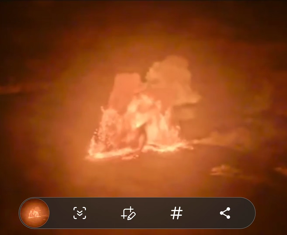
Her body rising

Tutu Pele sending a heart out for her beautiful Hawaii
Let's take a look at all the current updates on usgs ! We will start with the actual red alert level daily update, and go into webcam images at this current time (11:36 am Hawaii time) as well as all the links to find everything on USGS and stay updated , maps deflation data earthquakes etc .) This is super relevant to our entire #AOLEPGV fight , as they are completely desecration Kilauea Volcano, one of the planets most active volcanoes . (Tutu Pele IS our PUNA CULTURE . Scroll for AMAZING PHOTOS OF HER RISING UP FROM THE LAVA THE MOMENT IT ERUPTED !!)
Alert Level: WARNING, Color Code: RED
2023-06-07 19:02:22 UTC
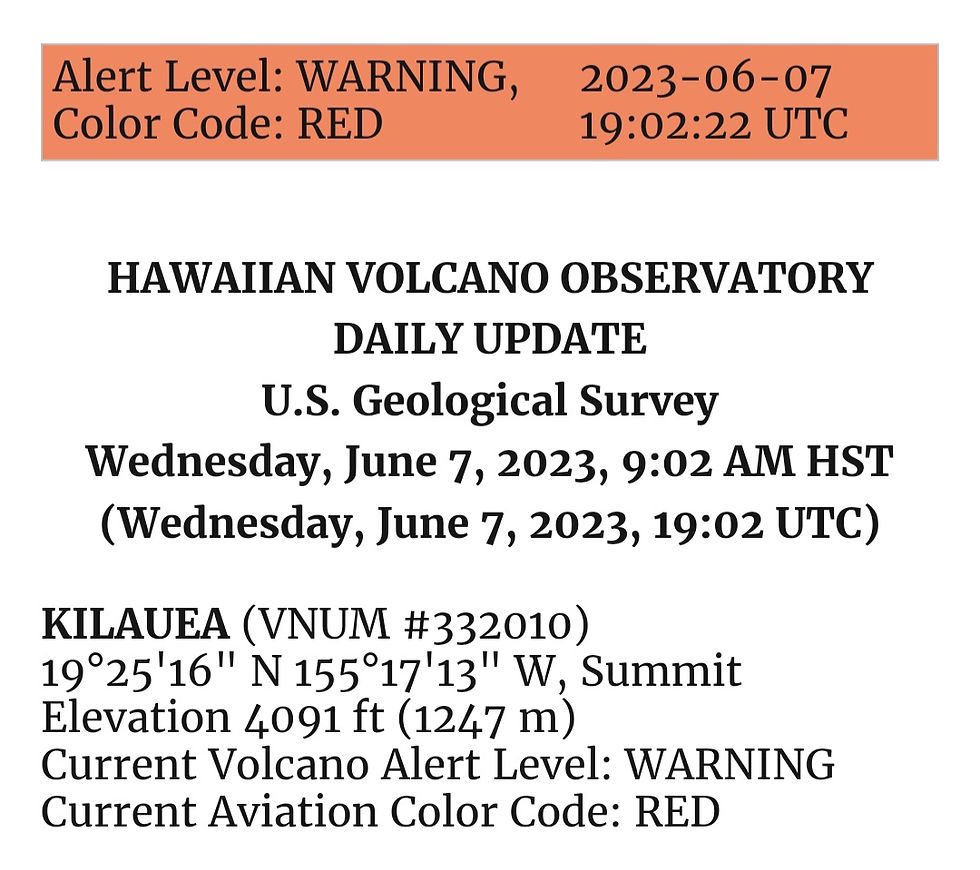
HAWAIIAN VOLCANO OBSERVATORY DAILY UPDATE
U.S. Geological Survey
Wednesday, June 7, 2023, 9:02 AM HST (Wednesday, June 7, 2023, 19:02 UTC)
KILAUEA (VNUM #332010)
19°25'16" N 155°17'13" W, Summit Elevation 4091 ft (1247 m)
Current Volcano Alert Level: WARNING
Current Aviation Color Code: RED
Activity Summary: Kīlauea volcano is erupting. Eruptive activity is currently confined to Halemaʻumaʻu crater within Kīlauea's summit caldera. No unusual activity has been noted along Kīlauea’s East Rift Zone or Southwest Rift Zone. Kīlauea’s volcano alert level and aviation color code will remain at WARNING/RED as this new eruption and associated hazards are evaluated.
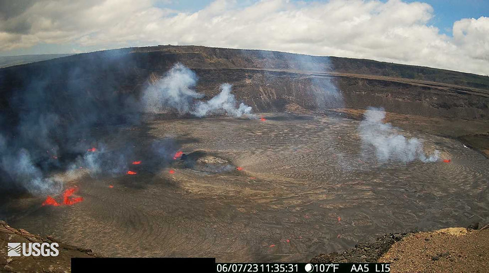
Halemaʻumaʻu Lava Lake Observations: Multiple minor fountains are active in the central eastern portion of Halema‘uma‘u crater floor and one vent is open on the west wall of the caldera, within the closed area of Hawai'i Volcanoes National Park. The largest lava fountain is consistently about 15 meters (50 feet) high; during the early phase of the eruption, fountain bursts reach at least approximately 60 meters (200 feet) high. Lava flows have inundated much of the crater floor (an area of approximately 370 acres or 150 hectares). As of approximately 8:00 a.m. about 10 meters (33 feet) depth of new lava had been added to the crater floor. A live-stream video of the crater is available at https://www.youtube.com/usgs/live.
Summit Observations: Summit tilt switched from inflation to deflation around 5 a.m. HST, shortly after the eruption onset. Summit earthquake activity greatly diminished following the eruption onset and eruptive tremor (a signal associated with fluid movement) resumed. Volcanic gas emissions in the eruption area are elevated .
Rift Zone Observations: No unusual activity has been noted along the East Rift Zone or Southwest Rift Zone; steady rates of ground deformation and seismicity continue along both. Measurements from continuous gas monitoring stations in the middle East Rift Zone—the site of 1983–2018 eruptive activity—remain below detection limits for SO2.
Hazard Analysis: The eruption at Kīlauea’s summit is occurring within a closed area of Hawai'i Volcanoes National Park. Therefore, high levels of volcanic gas are the primary hazard of concern, as this hazard can have far-reaching effects down-wind. Large amounts of volcanic gas—primarily water vapor (H2O), carbon dioxide (CO2), and sulfur dioxide (SO2)—are continuously released during eruptions of Kīlauea volcano. As SO2 is released from the summit, it will react in the atmosphere to create the visible haze known as vog (volcanic smog) that has been observed downwind of Kīlauea. Vog creates the potential for airborne health hazards to residents and visitors, damages agricultural crops and other plants, and affects livestock. For more information on gas hazards at the summit of Kīlauea, please see: https://pubs.er.usgs.gov/publication/fs20173017. Vog information can be found at https://vog.ivhhn.org/.
Additional hazards include Pele's hair and other lightweight volcanic glass fragments from the lava fountains that will fall downwind of the fissure vents and dust the ground within a few hundred meters (yards) of the vent (s). Strong winds may waft lighter particles to greater distances. Residents should minimize exposure to these volcanic particles, which can cause skin and eye irritation.
Other significant hazards also remain around Kīlauea caldera from Halemaʻumaʻu crater wall instability, ground cracking, and rockfalls that can be enhanced by earthquakes within the area closed to the public. This underscores the extremely hazardous nature of Kīlauea caldera rim surrounding Halemaʻumaʻu crater, an area that has been closed to the public since late 2007.
For discussion of Kīlauea hazards, please see: https://www.usgs.gov/observatories/hawaiian-volcano-observatory/hazards.
Please see the Hawaiʻi Volcanoes National Park website for visitor information: https://www.nps.gov/havo/index.htm. Visitors to Hawaiʻi Volcanoes National Park should note that under southerly (non-trade) wind conditions, there is potential for a dusting of powdery to gritty ash composed of volcanic glass and rock fragments. These ashfalls represent a minor hazard, but visitors should be aware that such dustings at areas around the Kīlauea summit are possible.
The Hawaiian Volcano Observatory (HVO) continues to closely monitor Kīlauea volcano.
HVO will continue to issue daily Kīlauea volcano updates until further notice. Additional messages will be issued as needed.
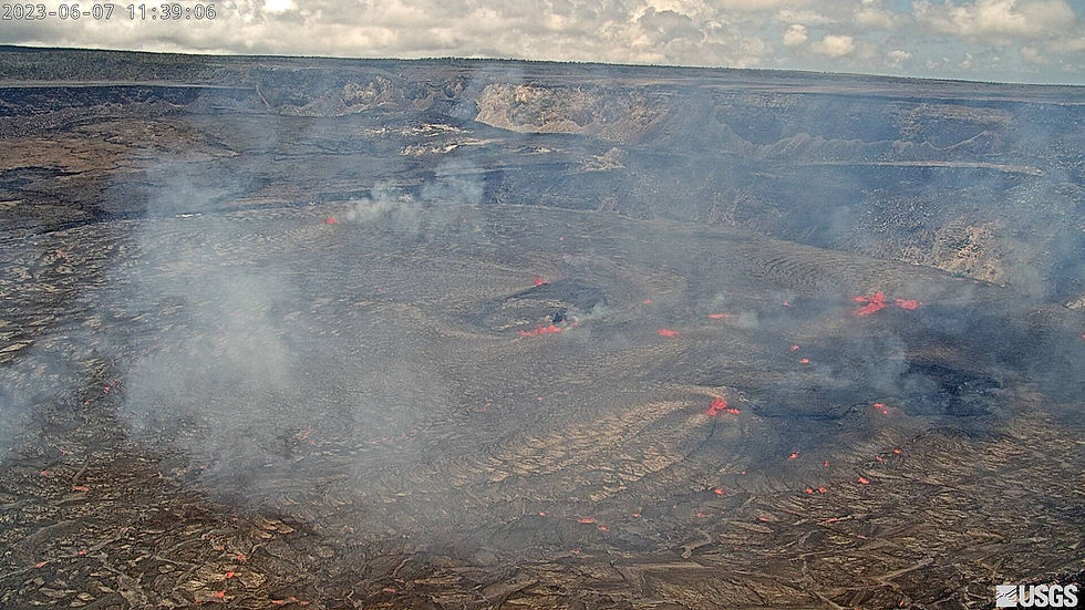
Live USGS Webcam images 1140am 06072023---
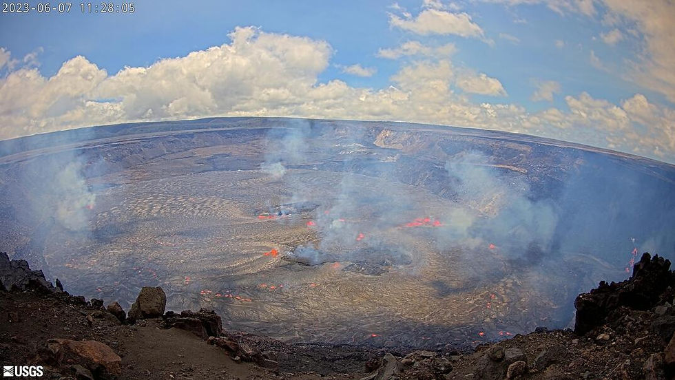
Halemaʻumaʻu, lava lake, and down-dropped block [KWcam]
From the west rim of the summit caldera, looking east. time stamp on image .

Halemaʻumaʻu and lava lake - thermal image [F1cam]
From the west rim of the summit caldera, looking east.
West vent in Halemaʻumaʻu crater and lava lake [V1cam]
From the northwest rim of the caldera, looking south.
Halemaʻumaʻu crater and lava lake from the crater rim [S1cam]
View is from the south rim of Halema‘uma‘u.
Lots more live webcam images on usgs site !
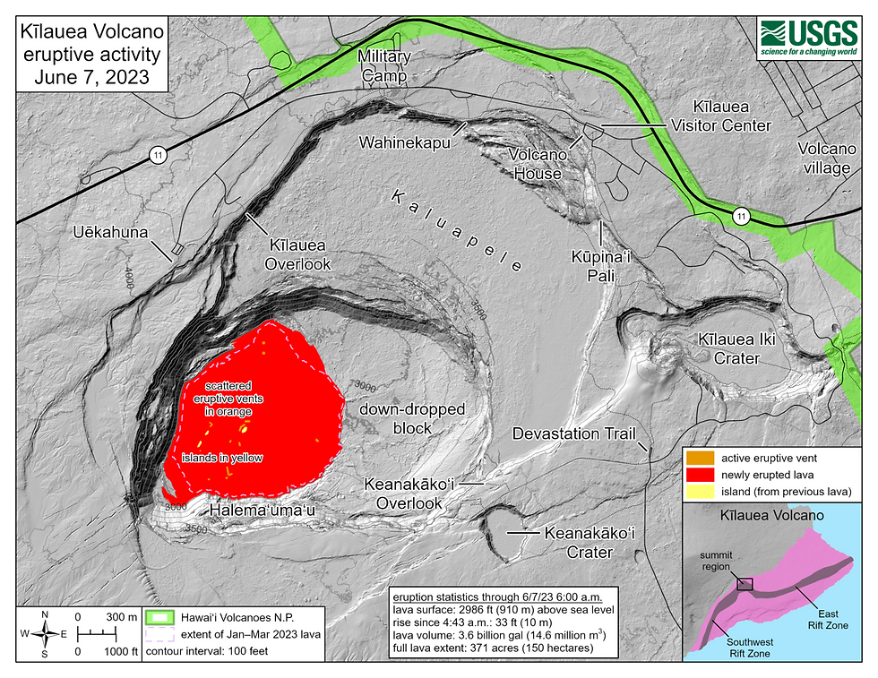
Map of first 2 hours of eruption
All links for kilauea eruption information--
More Information:
Kīlauea activity summary also available by phone: (808) 967-8862
Kīlauea webcam images: https://www.usgs.gov/volcanoes/kilauea/webcams
Kīlauea photos/video: https://www.usgs.gov/volcanoes/kilauea/photo-and-video-chronology
Kīlauea lava-flow maps: https://www.usgs.gov/volcanoes/kilauea/maps
Kīlauea FAQs: https://www.usgs.gov/volcanoes/kilauea/faqs
The Hawaiian Volcano Observatory is one of five volcano observatories within the U.S. Geological Survey and is responsible for monitoring volcanoes and earthquakes in Hawaiʻi and American Samoa.
CONTACT INFORMATION:
Subscribe to these messages: https://volcanoes.usgs.gov/vns2/
Summary of volcanic hazards from eruptions: https://www.usgs.gov/observatories/hvo/hazards
Recent earthquakes in Hawaiʻi (map and list): https://www.usgs.gov/observatories/hvo
Explanation of Volcano Alert Levels and Aviation Color Codes: https://www.usgs.gov/programs/VHP/volcanic-alert-levels-characterize-conditions-us-volcanoes
Aloha always,
Jazzy
KahuPuna
Aloha Activism

Comments